
India Approves Five Carbon Capture Testbeds to Cut Cement Industry Emissions
The Indian government and top science groups just said yes to five new carbon capture projects in the cement industry. These testbeds, built together with famous colleges and big cement companies, will show how to use captured carbon dioxide for useful things like fuels and chemicals. The move is part of preparing for climate goals and upcoming global rules on carbon.
India’s cement factories put out about 235 million tonnes of carbon dioxide each year, making up around 7% of the country’s total. These five new testbeds are meant to find ways to bring that number down, maybe by as much as 35% to 45% in the future, but the exact amount isn’t known yet.
India’s efforts show a strong push to fix climate change and help industries get ready for stricter global carbon rules.
For the complete story and full context, please refer to the original article from timesofindia.indiatimes.com.
Many Indian States Face Heat, Rain, and Moving Monsoon Mid-May
The India Meteorological Department (IMD) says some Indian regions will see warm nights, heat waves, humid weather, rainfall, thunderstorms, and a moving monsoon between May 15-20. Areas like eastern Madhya Pradesh face warm nights on May 15, while others like Uttar Pradesh and Rajasthan expect heat waves. Islands and southern states might get heavy rain. Rainstorms with strong winds are likely in northwest India. Monsoon will move further soon.
Recent years have brought many more heatwave days in some Indian states, showing a nineteen-times increase. Heavy rainfall events are also happening more often; for example, places like Karnataka, Odisha, and Bihar had over 1,250 heavy rain incidents each year from 2014 to 2023.
The upcoming week looks tough for many people as hot, wet, and stormy weather will affect several Indian areas.
For the complete story and full context, please refer to the original article from downtoearth.org.in.
India To Face Dusty Winds, Rain, And Rising Heat Mid-May
The India Meteorological Department has warned that dust storms with winds of 25-35 kmph could sweep through northwest India between May 16-18. Heavy rain is expected in scattered parts of the country until May 19. In the coming days, maximum temperatures in central and western regions may climb by 2-4°C. Conditions also favor the southwest Monsoon moving forward soon.
For people living in Rajasthan, Punjab, Haryana, and western Uttar Pradesh, strong dust storms are pretty common every May. These storms often bring winds between 30-50 kmph. In past years, like 2018, wind speeds during such events have gone even higher, sometimes above 40 kmph.
With rising temperatures and the Monsoon on its way, people across India should stay prepared for fast-changing weather.
For the complete story and full context, please refer to the original article from downtoearth.org.in.
Thick Dust Causes Poor Air and Low Visibility in Delhi-NCR Morning
People living in Delhi and NCR woke up to dusty air and bad visibility on Thursday morning. Dust from North Pakistan and winds blowing at 30-40 kmph quickly dropped visibility from 4,500 metres to 1,200 metres between 10 pm and 11:30 pm. The Air Quality Index jumped from 135 to 249. Experts say this started overnight and may improve with rain expected Today.
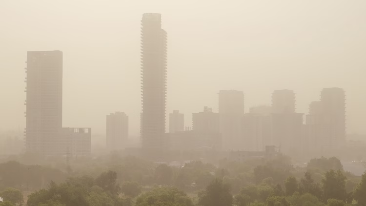
Dust storms like this happen in Delhi-NCR every year. Sometimes, the air gets much dustier and visibility can fall to just 1,200 metres. Lately, reports and numbers suggest these pre-monsoon dust events are getting stronger, but clear information about health risks from the latest dust spell is still missing.
Residents should be careful when air is dusty. The weather department thinks rain this Friday could help clear the air soon.
For the complete story and full context, please refer to the original article from indiatoday.in.
India Sees Early Monsoon Reaching Andaman Islands and Bay of Bengal in May 2025
The India Meteorological Department (IMD) said on May 13, 2025 that the southwest monsoon had already reached parts of the south Bay of Bengal, south Andaman Sea, Nicobar Islands, and some north Andaman Sea.
Normally, these places get monsoon rain by May 18-19, but this year it came several days early. Strong winds, increased rain, and less heat escaping were key signs. Kerala could see rain by May 27.
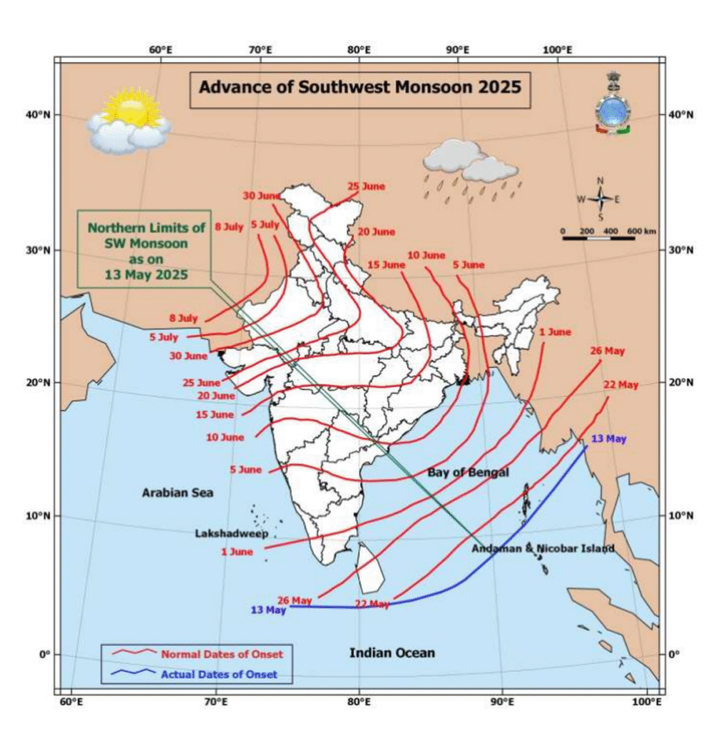
Usually, the monsoon starts in the Andaman area roughly around May 19, based on the years 2015 to 2024. The rain starting on May 13 this year means it has come almost a week earlier than the ten-year average starting date for these islands.
Early rains may help farmers, but can also surprise people who are not ready. Watching the weather closely is important for everyone.
For the complete story and full context, please refer to the original article from indiatoday.in.
Perito Moreno Glacier Calving Increases, Scientists Blame Warming and Less Snowfall
Scientists such as Lucas Ruiz from CONICET, guides like Pablo Quinteros, and tourists have noticed more large ice chunks breaking away, or calving, from Argentina’s Perito Moreno Glacier.
In the last 4 to 6 years, it started retreating and losing 1 to 2 meters of water each year, after decades of steady size. Experts say climate change—meaning hotter temperatures and less snow—causes this.
Earlier, the glacier lost 250 to 330 million metric tons every year, but since 2020, even bigger and more often breaks happen, though the exact yearly total for recent times isn’t clear. Still, the intensity of ice loss seems much higher now.
This glacier’s rapid changes show how warming and less snow affect even places thought stable for decades.
For the complete story and full context, please refer to the original article from reuters.com.
Huge Solar Eruption May Spark Northern Lights and Cause Power Worries
On Tuesday, scientists, including aurora hunter Jure Atanackov and space expert Dr Tamitha Skov, watched as a giant, wing-shaped blast shot from the sun’s north side. This eruption was so huge the solar plasma stretched more than 600,000 miles, which is twice the distance from Earth to the moon.
This event happened because the sun’s magnetic fields became shaky, letting cooler, thick layers of solar “goo” escape—an event called a coronal mass ejection or CME, explained by astronomer Jake Foster. NASA’s satellites saw these fired particles fly off into space.
Most of the blast will miss us, but a little bit could reach Earth tomorrow. Experts say there’s about a 20% chance of a big space storm. If it happens, it could mess up phones, power, or radios, though the risk stays low.
Some people might see extra bright Northern Lights, especially if they live in places like northern Scotland with clear skies.
Scientists are watching the sun closely, but they think the most serious problems or strong auroras are not very likely this time.
For the complete story and full context, please refer to the original article from dailymail.co.uk.